Switzerland has not fought a war in over 500 years. But hidden inside its mountains lies one of the most extensive military fortification networks ever built: a system so vast, so meticulously engineered, and so deeply embedded in the national psyche that it fundamentally shaped what Swiss neutrality actually means.
The National Redoubt — Réduit national in French, Schweizer Reduit in German — was not a single bunker or even a single plan. It was a doctrine that evolved across 140 years, through two world wars and a Cold War, from a handful of Victorian-era forts guarding a railway tunnel to a network of over 20,000 military installations capable of turning the entire Alpine heartland into an impenetrable fortress.
This is the story of how the most peaceful country in Europe prepared for the most violent possible future — and how that preparation may have been the very thing that kept the peace.
The Seeds: 1880s–1914
The story begins not with a war, but with a railway.
When the Gotthard Railway opened in 1882, connecting northern and southern Europe through a 15-kilometre tunnel beneath the Swiss Alps, it transformed Switzerland’s strategic position overnight. The country was no longer just a neutral buffer between its neighbours — it was now the custodian of a critical continental transit route.
The broader geopolitical context made the vulnerability urgent. The unification of Germany in 1871 and of Italy in 1870 had created two powerful nation-states on Switzerland’s borders for the first time. The balance of power that had sustained Swiss neutrality since the Treaty of Paris in 1815 was shifting. If a foreign power seized the Gotthard tunnel, it would control one of the most important north-south transportation links in Europe.
Swiss military planners recognised the threat immediately. In 1886, Switzerland began constructing its first significant defensive fortifications near the Gotthard Pass. Engineers built forts modelled on the designs of Belgian military architect Henri Alexis Brialmont at four critical points: Airolo (the southern mouth of the Gotthard tunnel), the Oberalp Pass, the Furka Pass, and the Grimsel Pass.
The Battery Motto Bartola, one of the earliest positions in the Gotthard complex, was constructed between 1888 and 1890. At Saint-Maurice in the western Valais, engineers used then-pioneering mining and tunnelling techniques to carve artillery positions directly into the steep mountainsides of the glacial valley.
These early installations were modest by later standards, but they established a principle that would define Swiss defence thinking for the next century: the Alps themselves were the weapon. The fortifications simply gave them teeth.
By 1914, Switzerland had three nascent fortress zones — Gotthard, Saint-Maurice, and the beginnings of what would become Fortress Sargans in the east — positioned to control the alpine crossings between Germany and Italy. During the First World War, Switzerland mobilised its army but was never attacked. The Redoubt concept remained theoretical.
That would change.
<
The Interwar Gamble
After the First World War, interest in fortification waned. Switzerland had maintained its neutrality throughout the conflict, and there seemed little appetite for pouring money into mountain bunkers.
That calculus shifted dramatically in the 1930s. Across Europe, nations were building defensive lines at unprecedented scale — France constructed the Maginot Line, Czechoslovakia built extensive border fortifications, Germany was hardening the Siegfried Line. Switzerland watched, and recalculated.
The timing intersected with the Great Depression. Swiss job creation programmes in the mid-1930s provided both the labour force and the political will for a major expansion. Design work started in 1935, and by 1937 construction was underway on a vastly expanded network encompassing not just the alpine forts but a new Border Line along the Rhine and an intermediate Army Line across the Swiss Plateau.
Three strategic nodes were identified as the anchors of the entire system: Fortress Saint-Maurice in the west, controlling the Rhône valley and the approaches from France. Fortress Saint Gotthard in the centre, guarding the critical north-south rail and road links.
And Fortress Sargans in the east, defending the Rhine valley gateway into the Alps — a position made newly vulnerable after a drainage programme converted the wetlands along the Rhine into terrain an armoured force could cross.
Together, these three fortress complexes formed an east-west defensive line through the heart of the Alps. The territory they enclosed — roughly the mountainous central quarter of Switzerland — would become the Réduit.
The Architect: General Henri Guisan
When war returned to Europe in 1939, Switzerland found itself in an almost impossibly precarious position. By June 1940, France had fallen in six weeks. Switzerland was now entirely surrounded by Axis powers — Nazi Germany to the north and east, Fascist Italy to the south, and Vichy France to the west.
The man tasked with defending the country was General Henri Guisan. On 30 August 1939, the Swiss Federal Assembly had elected him commander-in-chief of the armed forces with 204 votes out of 231 — only the fourth person in Swiss history to hold the wartime rank of general, a position that exists only in times of war or national emergency.
Guisan understood the arithmetic immediately: Switzerland had roughly 430,000 combat troops.
Germany had millions. In a conventional war fought on open ground, Switzerland would be overrun in days. But Guisan was not planning a conventional war. He was planning a retreat.
The strategy Guisan developed — refined by his chief of staff, Colonel Samuel Gonard — was built on a brutal calculation. Switzerland could not defend its borders, its cities, or its industrial heartland. What it could defend was the Alps. And what it could deny to any invader was the thing every invader would want most: the alpine transit routes connecting Germany to Italy.
The plan involved three concentric defensive layers. First, a “Border Line” of fortifications along the Rhine and in the Jura, designed not to hold but to delay. Second, an “Army Position” further back in the Swiss lowlands, again intended as a fighting retreat. And third — the core — the National Redoubt itself: a fortified alpine perimeter connecting the three great fortress complexes.
If Switzerland were invaded, the army would fight delaying actions through the first two layers while falling back into the mountains. Once inside the Redoubt, the Swiss would destroy every bridge, tunnel, and railway behind them, making the transit routes useless to the enemy. As a last resort, they were prepared to demolish their own infrastructure — including hydroelectric dams — rather than let it fall into enemy hands.
It was, in essence, a plan to sacrifice everything except the mountains — and to make the mountains unconquerable.
The Rütli Address: 25 July 1940
Two days after France surrendered, on 23 June 1940, Guisan ordered the border zones reduced in priority and began shifting the army toward the centre of the country. On 12 July, the final plan was adopted by the Federal Council. On 25 July, Guisan delivered it to the Swiss officer corps at one of the most symbolically charged locations in Swiss history: the Rütli meadow on Lake Lucerne, the legendary founding site of the Swiss Confederation.
The so-called Rütlirapport was both a military briefing and a piece of political theatre. By choosing the Rütli — where, according to tradition, the original three cantons swore the oath that created Switzerland in 1291 — Guisan was drawing a direct line between the nation’s founding mythology and its current existential crisis. He travelled by steamboat across Lake Lucerne with approximately 650 senior officers, who gathered in a semicircle on the meadow to hear him lay out the strategy of retreat, resistance, and absolute refusal to surrender.
His message was unambiguous: in the event of an attack, the Swiss would abandon the lowlands, retreat to the Alps, and fight to the last from inside the mountains. Every position would be held until ammunition ran out, then defended with bayonets. Machine gunners and artillerymen would fight as riflemen before they allowed their weapons to be captured. There would be no surrender. There would be no further retreat.
The gold reserves of the Swiss National Bank had already been moved from Zurich to the Gotthard Pass and Bern, farther from the German border.
The speech was deliberately leaked. Guisan wanted the Germans to hear it.
The strategy was not without its critics, even within the Swiss military. Some officers argued that preemptively conceding the lowlands signalled defeatism — that it told the enemy Switzerland’s most populated and industrialised regions could be had without serious resistance. Others questioned whether mountain fortifications, however formidable, could withstand sustained aerial bombardment. The debate was genuine, but Guisan’s authority — and the sheer lack of alternatives — carried the day.
Meanwhile, the Réduit existed alongside a more pragmatic reality. Switzerland made economic concessions to Germany throughout the war — continued trade, financial services, transit rights through the Gotthard railway. The strategy was to keep the overall cost of invasion higher than the benefits of Switzerland’s continued neutrality. It was deterrence through a combination of military threat and economic usefulness — a calculation as cold as the alpine rock the fortresses were carved from.
Operation Tannenbaum: The Plan That Never Was
The Germans had their own plans. Operation Tannenbaum (originally codenamed Operation Grün) was the Wehrmacht’s plan to invade Switzerland, developed in 1940. It envisioned a joint German-Italian assault: German forces would advance from the north to capture Geneva and Lucerne, while Italian divisions pushed through the alpine passes from the south.
Politically, the plan called for Switzerland to be dismembered along linguistic lines — the French-speaking cantons absorbed into Vichy France, the Italian-speaking Ticino handed to Mussolini, and the German-speaking majority incorporated into the Reich.
At its peak, the plan called for 21 German divisions (later reduced to 11), supplemented by approximately 12 Italian divisions — up to half a million Axis troops. Hitler personally despised Switzerland — he reportedly called it a “pimple on the face of Europe” and Joseph Goebbels branded it “this stinking little state.” German textbooks were already including the German-speaking cantons in maps of “Greater Germany.”
Captain Otto-Wilhelm von Menges, the German staff officer who drafted the invasion plan, assumed Swiss resistance was unlikely. He believed Switzerland would accept an ultimatum peacefully, as Austria had during the Anschluss. He could not have been more wrong.
German Chief of Staff Franz Halder studied the Swiss border terrain and concluded that the Jura frontier provided no favourable base for attack — the terrain rose in successive waves of forested hills across the axis of advance. He opted instead for a feint in the Jura to draw the Swiss army forward, then a flanking manoeuvre to cut their lines of communication — the same operational method that had defeated France.
But the plan was never executed. The main window of opportunity was the summer of 1940, but Hitler’s attention shifted to the Battle of Britain and then to Operation Barbarossa. Admiral Wilhelm Canaris, the head of German military intelligence and a covert anti-Nazi, reportedly exaggerated Swiss defensive capabilities in his assessments, further dampening enthusiasm for the operation.
And Switzerland’s usefulness as a neutral state — providing back-channel communications, financial services, and a trading window to the wider world — would have been eliminated by conquest.
Operation Tannenbaum was kept ready until 1944, when it was finally cancelled. Switzerland remained neutral. The Redoubt was never tested in combat. Whether it would have actually worked remains one of the great unanswered questions of military history.
Inside the Fortress: What Was Actually Built
The scale of construction was staggering. Between 1939 and 1945, Switzerland built approximately 20,000 military installations across the Alpine region. These included artillery fortresses equipped with 7.5 cm, 10.5 cm, and 15 cm guns; infantry bunkers; command centres; communications posts; ammunition depots; field hospitals; barracks; bakeries; and the infrastructure to sustain hundreds of soldiers inside each major fortress for months.
The three fortress complexes at the heart of the Redoubt were engineering marvels.
Fortress Saint-Maurice controlled the narrow Rhône valley in the western Alps — the only comparatively easy access to the upper Rhône valley and the western Redoubt. The fortress was not a single connected position but a network of mutually supporting forts carved into the mountains on both sides of the valley, dominating ten kilometres of the Rhône between Saint-Maurice and Martigny.
The principal fortification, the enormous Fort de Dailly, became one of the most heavily armed positions in Switzerland, supported by Forts Savatan, Scex, and Cindey. Higher-altitude positions were accessed by aerial cableways and inclined funiculars bored through the mountain itself. Virtually every bridge, tunnel, and choke point in the valley was fortified with blockhouses, anti-tank barriers, permanent minefields, or pre-surveyed artillery coverage.
Even industrial facilities like the Vezey hydroelectric plant had fortifications incorporated into their construction. Everything was camouflaged — light shells simulated rock formations, house-shaped superstructures disguised gun positions. The effective control of the Saint-Maurice positions extended from Lake Geneva to the Great Saint Bernard Pass.
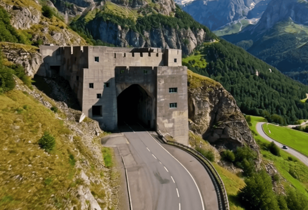
Fortress Saint Gotthard was the centrepiece — positioned in the geographic and symbolic heart of Switzerland, guarding the most important north-south transit route in the Alps. The complex centred on positions at Airolo, the Gotthard Pass itself, and extended through a network controlling the Oberalp, Furka, and Grimsel passes.
The most impressive installation was Sasso da Pigna, built between 1941 and 1945. This was not merely a gun emplacement — it was a complete underground military base. Cold, damp air fills the tunnels, accessed by an underground funicular that carries visitors deep into the heart of the rock, emerging not at a mountain view but at a command centre, artillery rooms, barracks with wooden bunk beds dressed in stiff khaki sheets, and strategy maps still hanging on the walls.
The complex was not declassified until 2001. Nearby, Fort San Carlo — now the subterranean La Claustra hotel — and numerous smaller installations completed the network. Hidden deep within the massif was also a secret 3,000-square-metre bunker near Amsteg, built to house the wartime cabinet.
Fortress Sargans anchored the eastern end, controlling the Rhine corridor and blocking advances toward the central passes. The complex comprised six major fortifications centred on Sargans in St. Gallen canton, including Fort Heldsberg — famously disguised as a civilian house with painted-on windows — Fort Magletsch (which remained in active military use well into the 21st century), Fort Schollberg, and Fort Furggels. Sargans was the most newly fortified of the three, made necessary by the Rhine drainage programme that had created an easy approach where none had existed before.
Cannon ports were hidden behind false rock faces. The programme produced dozens of Falsche Chalets — fake Swiss chalets that could open their walls to reveal artillery capable of devastating an advancing column.
The Redoubt was manned by eight infantry divisions and three mountain brigades. The Swiss had between 8,000 and 20,000 fortified positions (estimates vary because many remain classified), along with 16,000 machine guns, 400 field guns, and enough supplies to sustain prolonged operations without external resupply. Perhaps most remarkably, approximately 3,000 bridges, tunnels, and transportation chokepoints were rigged with demolition charges, ready to be destroyed at a moment’s notice. Many of these charges remained in place well into the 1990s.
The Cold War: Doubling Down
The Redoubt fortifications were modernised and expanded. New weapons systems were installed, including automatic 120 mm mortars and modern anti-tank guns through the “Bison project.” The Battery Foppa Grande in the Gotthard complex, representing this new generation of upgrades, was installed in 1953 and remained operational until 1997. In 1953, Swiss defence policy was formally revised to extend the concept of defence in depth — pioneered in the Redoubt — to the entire national territory, implicitly acknowledging cooperation with NATO while maintaining strict political neutrality.
The most dramatic expansion was on the civilian side. In 1963, following the Cuban Missile Crisis, the Swiss government passed the Federal Law on Civil Protection, mandating that every person in Switzerland must have access to a nuclear fallout shelter. New residential buildings were required to include shelters; where this was not possible, building owners paid into a fund for communal shelters.
The scale of what followed was extraordinary. The Sonnenberg civil defence shelter, built beneath the A2 motorway in Lucerne between 1970 and 1976 at a cost of 40 million Swiss francs, was designed to shelter 20,000 people — one-third of Lucerne’s population — behind four 350-ton blast doors. It was the largest civilian bunker ever built. By the 1990s, Switzerland had constructed over 360,000 shelters — enough space for 107% of its population. No other country on earth came close.
The Redoubt had evolved from a military doctrine into a national infrastructure — a permanent state of preparedness embedded in the architecture of every apartment block, school, and hospital in the country.
The Great Decommissioning — and the Revival
The end of the Cold War forced a reckoning. With the Soviet threat diminished, the enormous cost of maintaining thousands of military fortifications became increasingly difficult to justify. The Swiss army was reduced from 750,000 troops to 400,000 in 1995, and to 120,000 by 2004. The Army Reform of 1995 and subsequent Army XXI restructuring led to the closure and declassification of thousands of positions — approximately 13,000 installations were declassified in the late 1980s and early 1990s. In October 2010, Defence Minister Ueli Maurer proposed closing many remaining positions, estimating the cost of safe decommissioning at over one billion francs.
The decommissioning transformed the landscape in ways nobody had anticipated. Military bunkers were sold to private buyers, and the new owners got creative. Sasso da Pigna became a multimedia museum. Fort San Carlo became the La Claustra hotel. Former bunkers in Erstfeld and Stansstad became mushroom farms. A fortress near Giswil was converted into a cheese-ageing facility, with 90,000 wheels of raclette maturing in its tunnels. Others became wine cellars, ultra-secure data centres, and even nightclub venues.
But the story did not end with decommissioning. In 2022, Russia’s invasion of Ukraine reignited European security anxieties — and Swiss citizens began asking about their shelter assignments for the first time in decades. Inspections revealed that many shelters had deteriorated: doors that would not close, blocked escape routes, ventilation systems past their operational lifespan.
In September 2023, Lieutenant General Thomas Süssli announced that Switzerland would halt the sale of military bunkers. The army would instead seek to reintegrate fortifications into existing military infrastructure. A modernisation programme worth 220 million Swiss francs was launched to upgrade the shelter network over 15 years. The same month, parliament approved a 2.6 billion franc programme to clear the still-dangerous munitions depot at Mitholz — a WWII-era bunker that partially exploded in 1947, killing nine people, with 3,500 tons of explosive material still sitting beneath the village.
After decades of winding down, the Redoubt concept — or at least its infrastructure — was being revived.
Legacy: More Than Concrete
The National Redoubt was never used in combat. No enemy ever tested its defences. No Swiss soldier ever fired a shot from inside one of its mountain fortresses during an actual war.
And yet it may be one of the most successful military strategies in modern history — precisely because it was never tested. The Redoubt was designed as a deterrent, and by that measure it worked. Switzerland’s neutrality survived two world wars not because the Swiss were pacifists, but because they made the cost of invasion unacceptably high. The mountains were the weapon. The bunkers were the message.
For Switzerland, the Réduit became what geographer André Ourednik described as one of the places where the Swiss store memories, myths, and a part of their identity. The decision to sacrifice the cities to save the mountains — to value territorial integrity over population protection — is a peculiarly Swiss equation, one that makes sense only in a country where the mountains are not merely geography but founding mythology.
General Henri Guisan died on 7 April 1960. He remains one of the most revered figures in Swiss history — voted the fourth-greatest Swiss person of all time in a 2010 poll. His bronze equestrian statue in Lausanne was inaugurated in 1967 before a crowd of 70,000. A memorial plaque on the steamship Stadt Luzern commemorates the journey to the Rütli that defined a nation.
Today, the legacy of the Redoubt is visible everywhere — if you know where to look. In the fake chalets with painted-on windows. In the bunker beneath every apartment building. In the museum fortress on the Gotthard Pass where you can walk through tunnels carved to stop Hitler. In the cheese ageing in former ammunition stores. In the hotel rooms 100 metres below the surface of the Alps.
The mountains remember. And beneath them, 360,000 secrets wait.
Related bunker profiles: Sonnenberg · Sasso San Gottardo · Fort Heldsberg · Fortress Sargans · La Claustra
Sources & further reading: This article draws on official Swiss federal archives, the Swiss Federal Department of Defence (DDPS), the military histories documented at Fortress Fürigen and Sasso San Gottardo, and the extensive academic record of the Réduit National. For corrections, additional sources, or contributions to the bunker database, contact info@bunkersofswitzerland.com.